The Fourth Edition of the WODC Map and Guide is now available in print and
electronic formats
 Printed Maps
Order a printed copy of the WODC map on the order page.
Electronic Map
An electronic version of the WODC map is now available on your phone for
just $4.99. Once installed on your Android or iPhone, you can view
the map without needing cell service, and your GPS location appears in
real-time. To install the map on your phone:
1) Download and install the free Avenza app on your phone. (Skip
this step if you already have Avenza.)
Android:
https://play.google.com/store/apps/details?id=com.Avenza
iPhone:
https://apps.apple.com/us/app/avenza-maps-offline-mapping/id388424049
2) Start the Avenza app on your phone and create an account.
3) Purchase the WODC map from Avenza using the same account you just created:
https://store.avenza.com/products/wodc-map-fourth-edition-wonalancet-out-door-club-map
4) Go back to the Avenza app (on your phone) and download the map you just purchased.
5) Also be sure to read the back of the map
for complete trail descriptions and other important information!
Sorry, the process is a bit more complicated than we would like, but we're
confident you'll enjoy the end result.
Background
The
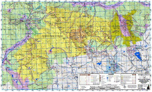
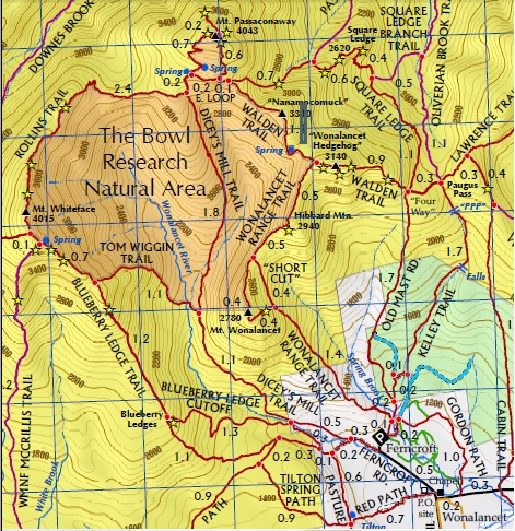
4th edition of the WODC map is printed and available for purchase. Once
again Mike Bromberg provided the excellent cartography and handled all of
the technical aspects of the update. Although the change list included 66
items there were only a few significant changes to trails. The most
significant were the relocation of McCrillis Path and the changes in
Waterville Valley due to Hurricane Irene. A number of snowmobile trails
between Rte 113A and Lake Chocorua were removed because of landowner
requests. The official declination shifted from 15.5W to 14.9W since the
3rd edition. Adjusting the declination was the final change to the map.
The members of the map committee included: Mike Bromberg, Peter Smart,
Doug McVicar, John Mersfelder, Mike Schneider, and Jack Waldron. The US
Forest Service provided excellent cooperation in the person of Dylan Alden
from the Saco District and John Marunowski from the Pemi District. Steve
Smith, who is the Editor of the AMC White Mountain Guide as well as the
owner of the Mountain Wanderer Map and Book Store in Lincoln, provided us
with much useful information, particularly on the changes in Waterville
Valley.
The physical production of the map and envelope took longer than previous
editions. This was due to a sharp increase in the price of Tyvek.
For the 3rd Edition paid $1.65 per map, the 4th Edition cost $3.65 per
map. Because of the sticker shock associated with the price increase we
examined alternative materials. These included using a thinner sheet of
Tyvek or substituting other impact resistant materials such as Paper
Tiger, a laminated paper and plastic product. None of these materials
provided the same feel and toughness as Tyvek so we chose to accept the
higher cost. The map was printed by Williams and Heintz Map Corporation of
Capitol Heights MD who also printed the 3rd Edition. They provided us with
valuable information and guidance as we explored Tyvek alternatives. The
Tyvek envelopes were printed by Minuteman Press of Conway. Due to the
increased costs of production we have changed the retail price of the map.
WODC members who purchase the map directly from the club will still pay $6
per map. The suggested retail price will be increased from $8 to $10 per
map.
 The
final issue that the map committee wrestled with is digital distribution.
We did not find an App such as Gaia GPS where the WODC map could be
provided as a digital download with all the GPS information intact and
usable. The state of the art hasnt reached the point where there is a
portable map format similar to the portable document format (pdf) that is
available for digital documents. Nevertheless we will make the WODC map
available as a pdf on our website that can be freely downloaded to a smart
phone or other digital device. The current size of the WODC map in pdf
format is 10Mb. We are working to decrease that size so that the
information is usable but the download time can be significantly
shortened. Watch our website (wodc.org) for information on pdf downloads.
The
final issue that the map committee wrestled with is digital distribution.
We did not find an App such as Gaia GPS where the WODC map could be
provided as a digital download with all the GPS information intact and
usable. The state of the art hasnt reached the point where there is a
portable map format similar to the portable document format (pdf) that is
available for digital documents. Nevertheless we will make the WODC map
available as a pdf on our website that can be freely downloaded to a smart
phone or other digital device. The current size of the WODC map in pdf
format is 10Mb. We are working to decrease that size so that the
information is usable but the download time can be significantly
shortened. Watch our website (wodc.org) for information on pdf downloads.
Philosophically, we do not view our map as a profit center but rather as a
service we provide to not only educate hikers on trails and peaks but also
to provide information that enhances their safety. We donate maps to NH
Fish and Game for each of the Conservation Officers. One Conservation
Officer, who shall remain anonymous, told us that the WODC map is
absolutely the best map to use in managing a Search and Rescue operation
in the Sandwich Range.
Please click here for
order form. The map will also be available at local stores and outdoor
shops including: